 Almost everything that a city or county government does or any service they provide is tied to an address.
Whether it is firefighters responding to a 911 call, public works staff responding to work orders, or an individual applying for a street-parking permit, the ability of a city or county to provide services depends on knowing the address of where someone or something is located.
Addressing Across the Enterprise Has Long Challenged Local Governments
To meet this need for address data, individual departments within local governments often develop their own solutions for entering, maintaining and using address data. This can range from a list of addresses in an Excel spreadsheet to a highly vertical application/database. Few systems have been designed to manage and share addresses across departments and applications.
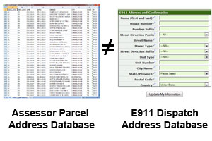
For example, a county’s E911 dispatch addressing system and assessor parcel addressing database are typically managed by several people in different departments with greatly differing jurisdictions and priorities. Across departments, the same basic address data might be entered twice using different standards. Consequently, address management systems usually do not sync-up. This duplication is not only a waste of time, it opens the door to errors, inconsistencies, lost revenues and poor customer services.
Why is Standardized Addressing so Challenging?
Standards for address management do exist, and some local governments do use GIS to try and manage addresses in a more formal way. But this approach requires a county or city government to have trained technical staff to key address data into a GIS. Moreover, the underlying GIS typically aren’t address-centric so a GIS operator needs to do significant work to make the GIS system understand how to manage an address. Perhaps even more problematic, the GIS operators aren’t the people using the addresses. So you’re asking someone who isn’t going to use the data to be managing the data.
It’s tempting to try and give the people who actually rely on addresses GIS tools to help maintain the data. Unfortunately, most people don’t have the time to learn GIS, let alone manage it. And their department probably doesn’t have the money to allocate to the yearly licenses and on-going training.
The Enterprise Addressing System Solution
That’s the context and motivation behind the development of the Enterprise Addressing System (EAS), an Open Source web-based master address repository, maintenance, management, query and validation system that Farallon developed in partnership with the City and County of San Francisco.
Our motivation for developing the EAS was driven by a couple of fundamental facts:
- Addresses are critical data
- Its a challenge to keep address system up to date
- Its almost impossible to keep systems synced across departments
- You can’t ask departmental staff to manage addresses using traditional desktop GIS tools because the technology’s too challenging and too expensive
Creating an Addressing System Users Want and Know How to Use
Our first priority was to make the EAS easy-to-use. This required the EAS to be web-based in order to ensure that all address users could easily access, maintain and update addresses from a single authoritative database. This also meant that the rules that go into confirming address data are complete and valid, would need to be transparent to the people using the EAS.
An EAS user doesn’t have to know anything about how to access addresses data or how to confirm that addresses are valid. If for example, you’re working at a help desk or you have to confirm that an address actually exists before you can take the next step in your workflow, such as issuing a permit, you just log in to this web application and type in an address. Its either there and you find it or if it isn’t, the system shows you the nearest valid address. With the EAS, getting access to the authoritative data is simpler and you know it’s consistent across every department.
Part II – Addressing Maintenance Workflows & Open Standards
In the next post in this blog series on the EAS I will talk about the maintenance workflows as well as the use of standards


