Like many people, I cut my teeth in the database world using MS Access. And, early in my career, I was much more comfortable writing queries using Access’s sql GUI than I was writing sql in a command prompt. As such, it was common practice for me to make ODBC links to my Oracle Spatial database, and use Access as the interface to do the actual querying.
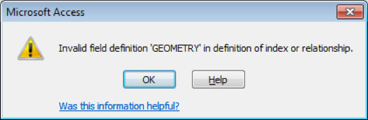
In the case of Oracle Spatial though, there was one problem – when I tried to link to a table that had a column of sdo_geometry data type, I got this error:
Invalid field definition ‘GEOMETRY’ in definition of index or relationship
The solution?… you’re gonna laugh. Make a view in Oracle that excludes the geometry column and connect to that instead of the base table.