 Managing water resources and water resources infrastructure is of growing importance worldwide. Here in California water resource management is increasingly a hot topic because of our growing population and the impacts of climate change – where is the water, where are the pipes, where are the pumps & equipment, where are the people the water flows to, etc – all of this information needs to be collected, managed and understood, in order to make intelligent decisions.
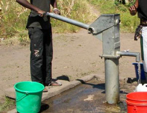
As serious as our water resources infrastructure management issues are here in California, they are even more pressing in developing countries in Africa. Whether at a village, NGO or regional government level there needs to be some way to understand where assets (from hand pumps to seasonal water sources) are located, what condition they are in and how they vary over time.
A GIS asset management system address these issue in a highly effective and when done right, a cost-effective manner.
I have a lot to say on these topics, but will summarize the important bits as follows:
- The core role of GIS in asset management is to act as the authoritative inventory of a water system assets. The GIS is the final word on the “what and where” of your system assets. The actual work of managing your assets (the “workflows” that you use to inspect, repair, monitor, and extend your water system) will all rely on this spatially referenced inventory.
- By far, the most valuable and important component of your GIS will be the database that you use to store and manage the asset data in a secure and flexible manner. Organizations will want to use a relational database management system capable of working with geometries (such as points, lines, polygons, geo-referenced images) natively. Most of the standard databases can now store, index, query, and process geometries. To me, PostgreSQL with the PostGIS extension is the relational database that best balances capability and ease of use.
- The most cost effective, but also some of the most innovative GIS solutions use Open Source software. PostGIS is an open source database. GeoServer is a great spatial server. OpenLayers is a great web application client framework. QGIS is a very good desktop GIS. All are Open Source. And all can be obtained for free. As for support, companies like Farallon and OpenGeo provide support for these technologies.
- Because asset data will be the most valuable portion of any system, encoding information in openly published data formats is important. By this I mean that data should be accessible without requiring the purchase or use of a single, vendor controller API. OGC standards ensure this. And integrating your GIS with other systems should be done using web services that use standard and open encodings such as JSON (JavaScript Object Notation) and REST (Representational State Transfer) patterns.
- Collecting data in the field needs to be simple, inexpensive, and fool-proof so that your users get complete and valid information. In my opinion, the latest smart phones (like Android and iPhones) and tablets (like the iPad and the coming wave of Android-based tablets) are becoming the best platforms for collecting data in the field. We’ve done several field data collection projects using Android phones/tablets, and they work extremely well.
- Even with all this discussion concerning technology, I must say that technical bits usually end up being the easiest part of any system development. The challenge is to truly understand how to build solutions that make it easier for people to d
o their jobs. This means understanding your users information requirements, designing easy to learn and robust workflows, making user interfaces easy to use, and deploying it all in a way that your clients can actually maintain without breaking their budgets.
Because this blog post is about resource management in developing countries where budgets and technological infrastructure are limited, I’ve focused my comments on Open Source Software, Open Data formats, and standards-based technologies. But the same principals on using a GIS for asset management apply to organizations with existing IT and GIS infrastructures using commercial software such as ESRI or Intergraph.
Farallon has a lot of experience in developing asset management systems for the developing world (e.g. Mega-J), as well as for the developed world (e.g. Union Sanitary District). Water systems, in particular, are an area in which we have a good bit of experience.