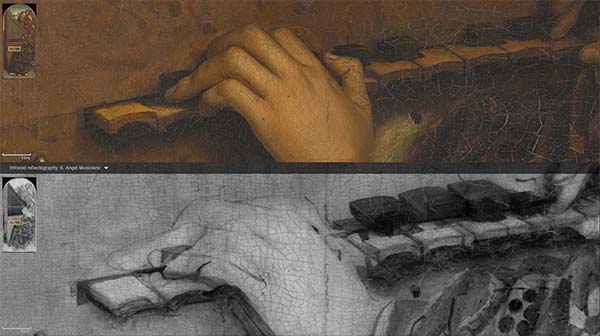
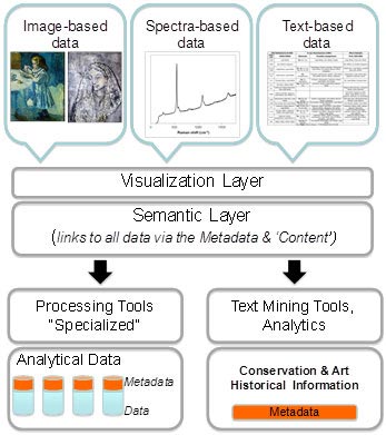
During an art analysis or restoration campaign, conservation scientists and art historians generate an enormous amount of data about an object or artist. This include digital images, spectral analysis as well as written observations. This information is used to drive conservation / restoration programs as well as inform historic, artistic and cultural interpretations.
However because there is not a standard system for comparing all data relating to an object (or group of objects), many conservation analyses are undertaken in isolation, with no consistent way to compare data across formats, locations or time periods. What’s needed is a way to integrate all the data relating to an object, group of objects, artist, time period or location, into a concise and accurate representation that facilitates making comparisons, finding correlations, and discovering new insights.
The DISCO project (Data Integration for Conservation Science) is intended to address this need. DISCO will be a software platform for conservation scientists to manage, integrate, discover, and use digital information to advance the conservation and understanding of works of art. The project is supported by Getty Conservation Institute and is being developed by Farallon Geographics.
Farallon has already conducted a review of existing relevant standards for the core data (i.e., technical conservation images and scientific data) and associated metadata, as well as existing relevant dedicated vocabularies and ontologies necessary to enable a linked open data approach to data integration. It also identified requirements for a data integration platform based on use cases and workflows from a variety of stakeholders in conservation/conservation science.
Farallon is now working with the Getty to develop the DISCO prototype. DISCO will build on the Arches platform for the core CRM ontology implementation, data management, thesaurus management, and search capabilities. This will immediately enable high-performance attribute, geospatial, and temporal search functionality.
The DISCO prototype development includes:
- Implement ontologies and thesauri to manage conservation data
- Development of resource graph creation and management workflows using CIDOC CRM ontology
- Implement Reference Data Manager, a SKOS with a compliant thesaurus management module
- Development of data entry form manager
- UI design, development, and functional review
- Development and testing of validated DISCO workflows
DISCO is an incredibly interesting project. Many of our team members from Farallon went on a field trip to the Getty for the opportunity to actually see the complexity and data richness of art restoration projects in action. It was a fascinating and illuminating visit. We’re excited to be a partner.