 I watched a lot of movies as a kid but one that really stuck with me over the years was the Robert Redford & Ben Kingsley flick, Sneakers. A movie about espionage, government secrets, cryptography and, yes, data. In the climax of the movie, Kingsley calls to Redford’s character and declares that “the world isn’t run by weapons anymore, or energy or money. It’s run by ones and zeros, little bits of data.”
I couldn’t agree more, and that is what I will be talking about today, how GIS is, at its core, run by ones and zeros. GIS is often confused with cartography, making pretty maps with spatial data. But it goes much further than that. GIS is about spatial DATA, first and foremost, and how spatial features relate to one another.
One of the biggest mistakes a GIS professional can make while developing new data is not thinking of the bigger picture, not asking the question “How is this GIS dataset going to interact with other data?” The answer to this question can guide the development process, refinement process and, eventually, the data maintenance strategy. The result is the best GIS data possible, data that answers questions and helps make better decisions.
So, it’s about getting the data right, getting it modeled correctly at the get go, and then letting people access it in a way that is easy and intuitive. You can have the most advanced GIS software known to man, but it is all for not if the data you will be working with is garbage. As the old IT adage goes, “garbage in, garbage out.”
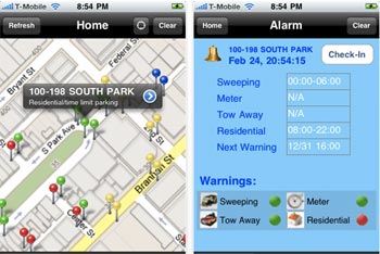
I recently completed work on an iPhone App whose primary functionality is to warn the user when they are in danger of violating a parking rule and thus, perhaps receiving a ticket if they don’t act quickly. The deliverable was the backend spatial database representing all the parking within San Francisco, as well as the various scenarios for each day of the week that dictate daily parking rules. If you have ever been to San Francisco and tried to park your car, you know firsthand how complex this data can get. You can’t park here from 8:00am-10:00am…unless it’s the 2nd or 4th week of the month. It’s only 2 hour parking after that, unless you’re a SF resident and have a specifically coded parking pass, or if you have….the scenarios go on and on.
Needless to say, many users of this app will be depending on the data being accurate. This required the design of a data model that allowed for information to be returned for multiple scenarios based on what week within the month it is, what day it is, what time it is, and most importantly, location of the user parking their car. If the data is wrong the user will most likely receive a ticket. Es no bueno!
In this example, the user is leveraging the functionality of an iPhone to access information in a database somewhere. This app is also available for the Android platform.
The accuracy of the underlying data is paramount to the interface accessing it. You could be using an iPhone, an Android tablet, Windows desktop, Ubuntu laptop through a data connection with AT&T 3G or Verizon 4G. It doesn’t matter how you access it, how you get to it, it just matters that the data is accurate and can help you make better decisions once you get there.


